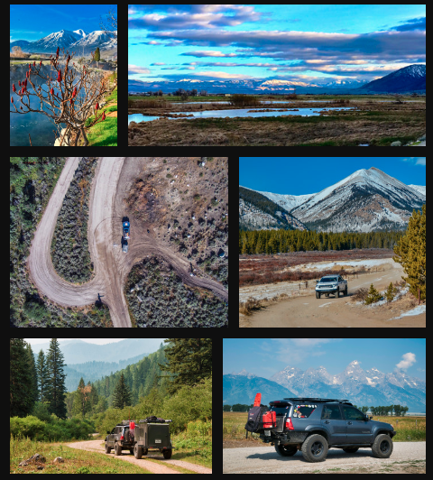
We traveled north on Highway 93 after refueling in MacKay, Idaho. This small, ranching community was a thriving cooper mining community in the early 1900’s. After passing the MacKay Reservoir, we aired down to travel on a winding, dirt single track road through the Idaho sagebrush. Since it was the beginning of June, the grass and sagebrush shimmered a bright green from winter’s runoff waters and the high, warm northern sun. We made a quick stop high above the Mackay Valley before we descended into Cooper Basin. Cooper Basin is a massive valley with flowing rivers, sagebrush covered plains and hills, and surrounded by the White Knob and Pioneer Mountains.
Brian and I discovered a lovely campsite just off the road along Cabin Creek in Cooper Basin. We cooked dinner and simply marveled at our surroundings: wild country with zero people. We claimed the basin all to ourselves! Just the way we like it! Brian and I cast a few into the water to see if any fish would take a late evening snack. Nope, no fish were hungry or at least not for what we offered. Instead, we admired the sunset views. The sun slowly dipped behind the mountains and simultaneously illuminated the clouds in pinks, reds, oranges, and purples.
The following morning, we motored toward the Pioneer Mountains. Along the way, we stopped at an old ranch situated along Star Hope Creek. Cattle still roam and feed on the grasses in the basin; however, on this day, we didn’t see any “slow moving elk.” We donned our backpacks and hiked to Bellas Lake. It felt good to stretch the legs and adventure deeper into the wilds of Idaho. We kept our eyes open for wildlife but saw none. We did spot glorious views the higher we hiked. Snowcapped mountains; lush wild, alpine flowers; and hearty-old trees surrounded us. As the trail leveled off, the high alpine environment and all of its beauty invited us to the lake. Snows from the winter melted in the warm sun as Brian and I rigged our fly fishing rods. Brook trout fed at the water’s surface, and we tied on a few dry flies. Lucky for us, the fish gobbled up our flies! We hooked one trout after another in this well-populated alpine lake. After landing numerous trout, we packed our gear and returned down the mountain.
Once back to our vehicles, we traveled northward. Miles of gravel roads led us through the Pioneer Mountains and past numerous mountain streams. Many dispersed camp sites abound for the adventurer to select, and we found a lovely spot along Wildhorse Creek. The campfire snapped, crackled, and popped as we sipped a smooth whiskey and watched the stars “dance” overhead.
Idaho has the most soakable, natural hot springs in the U.S. After a few days of traveling and hiking, we planned to stop at Gold Bug Natural Hot Springs. Lucky for us, only a few cars were parked in the lot. We started the hike to the springs. The trail followed a narrow, mountain river up into a steep-walled canyon. After an hour or so of hiking, we marveled at the natural springs in front of us. Cold and hot water cascaded through the canyon beneath hanging gardens and wild flowers. Brian and I had the springs all to ourselves. We wandered among and soaked in the many different spring’s pools; finding the one that was a perfect temperature. For several hours, we enjoyed the views down canyon. With our sore muscles and bodies soothed, we returned to our vehicles and headed northward.
“Sorry, that route is still closed due to snow,” the ranger informed me over the phone. Yes, snow in June is still possible and will potentially block high mountain passes. We scanned the map for a different area to explore.
“What about the St. Joe River,” asked Brian.
“Looks ideal. Let’s go!” I replied.
We drove forest road 282 up and over the Bitterroot Mountains from St. Regis, Montana, which dropped us directly to the St. Joe River in the northern panhandle of Idaho. Brian and I stood in awe of our surroundings. Just minutes earlier, we fueled up and enjoyed Huckleberry shakes in the busy tourist town of St. Regis; and now, we stood along the beautiful waters of the St. Joe with no one in sight. The river was ours!
Related Articles
I grabbed my fly rod and tied on a purple haze fly. I threw the fly into a slow eddy along the St. Joe River and immediately a 15-inch cutthroat engulfed my fly. Brian helped me land the beautiful fish. After, a few pictures, I released it back into the waters to fight another day. We were off to a great start on this leg of the adventure.
The St. Joe River is a clear, cold mountain river that flows from east to west for roughly 140 miles. The river is surrounded by a steep-walled canyon. Fortunately for the overlander, there is a nice road that parallels much of the river. Fish a spot and move on…. It was that simple. Brian and I headed eastward to the headwaters of the river to find a place to camp. Enormous White Cedar trees towered above our camp site as we savored our surroundings. The temperature cooled as the sun set behind the canyon walls, and we warmed ourselves around the fire—talking about life/politics and basically solving the world’s problems.
Brian was up early the following morning; he’s a morning person. He hiked to the river to fish. Once I started the day, I sipped coffee and appreciated the peace and serenity of our riverside camp. After my last sip, I hiked to river to test my skills and luck. Yes! I landed eight Brook and Cutthroat trout in a matter of 30 minutes. Brian and I joyously spent the day following the river westward. We would drive, stop, fish a hole (spot), and then move onto another spot. Throughout the day, we encountered no other people. We claimed the St. Joe as our private Idaho. We found a place to camp—a lovely, dispersed site off the St. Joe River Road. We started a fire, prepared dinner, and consumed a cocktail or two. It was a memorable day!
The next morning, we continued westward along the St. Joe. We stopped in Avery, Idaho, for fuel and some local insights from Dan at his fly shop, Idaho Fly Fishing Company. Avery, a quaint, small river town, is famous for its past citizens’ heroics during the The Great Fire of 1910. A massive, three-million-acre fire roared in the area during that summer, fueled by powerful winds and unusually dry conditions. It killed 86 people and is said to have burned enough timber to fill a freight train, 2,400 miles long! Ed Pulaski, a Wallace/Avery Ranger, saved 45 firefighters from Avery and Wallace by hiding out in a mining tunnel as the fire roared all around them. Ed developed the “Pulaski” (a combination of an adze and axe) which is a tool still issued to firefighters today. The forest outside of Avery was completely destroyed and, over time, has been reborn. It’s now a gorgeous, healthy forest. I refueled at the small general store in Avery before we headed southwest on the Marble Creek Road.
The dirt road meandered through the beautiful, evergreen forest. We stopped at Hobo Cedar Grove Botanical Area for a late lunch. After lunch, we hiked through the enormous, towering red cedar trees. Awestruck, we stared upward to comprehend the mass of these “skyscraper trees.” The hiking trail was lined with green ferns with water trickling along the trail, creating a serene scene.
Our dirt road continued to Elk River. Brian and I stopped at Tom’s Tavern to inquire from local folks about camping options. We sipped a beer, ate onion rings, watched a local rodeo on TV, and conversed with the locals. So fun! Later on, as recommended, we found a nice campsite among the towering evergreens.
“Wow!” Brian stated over the radio.
“Look at that bridge. It’s huge,” I responded.
The Dent Bridge spans the North Fork of the Clearwater River and is a little over 1500 feet long and towers 500 feet high. It’s the second highest bridge in the US, and it’s a massive suspension bridge in the middle of nowhere. Brian and I geeked out and flew our drones over and around the bridge in an attempt to capture its scale. There was no traffic on the bridge because it’s located off the beaten track. We were able to easily walk over the bridge. After a few photos, we continued our drive and topped off our fuel in Kooskia, Idaho. Back on pavement, we traveled eastward on Highway 12. This time we followed the Lochsa River.
After 80 miles of driving, we stopped for a soak at Weir Creek natural hot spring. This hot spring was just a short, 15-minute hike from the highway; the 103-degree water felt refreshing. As I soaked, I recalled our trip though the state of Idaho. We had traveled through numerous mountain ranges, fished countless rivers, and soaked in natural waters. Yes, the “Potato State” offers more than the nickname implies. Brian’s voice shattered the stillness of the moment: “Hey, you ready? Let’s go fish the Selway River. It’s up the road!” Yep, Idaho has so much more….
Trip Tibits and Insights
-Want to know more about The Great Fire of 1910? Read, The Big Burn: Teddy Roosevelt and the Fire that Saved America, by Timothy Egan
-Where are all those Idaho hot springs? Read, Hiking the Hot Springs of the Pacific Northwest, by Evie Litton and Sally Jackson
-Idaho fishing license can be purchased for daily use online, or at a local fly shop


