
iPad GPS Applications
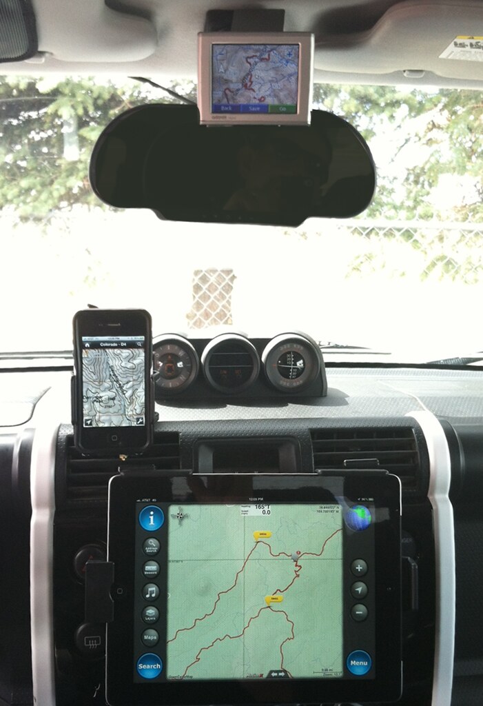 We installed the original iPad in our TRD just over a year ago because we knew it would be great for on-road navigation, off road maps, and music. We looked through many of the apps that were available at the time for a suitable backcountry, no internet service option and EveryTrail was the only app that came close. While EveryTrail still works fairly well, they haven’t yet created an iPad native version yet, so the 2X iPhone version on the new iPad is starting to look a little dated.
When FunTreks introduced their Data Cards last fall (See our October 2011 issue), which include the GPX tracks and waypoints for all trails in their books, we began looking for a better option to display the data and give us great terrain-based maps. While there are a number of applications that allow you to download maps for offline use (See “Other Apps” below), finding one that supports the IMPORT of GPX data directly into the app has been a challenge.
Thanks to help from users of ExpeditionPortal.com as well as other sites, we found a couple of apps that seem like they were built specifically for our FJ’s unique iPad Integration.
Gaia GPS
One of the most popular apps for overland and general 4×4 use. This is a great app that’s available for both iOS and Android devices, and is very feature rich. Gaia supports terrain, street, USGS topo, and Canadian Topo offline maps and also supports import of GPX files through or (new as of March 2012) through iTunes. This new update to support iTunes import makes this a very intriguing app. The user interface is pretty basic, which makes it easy to navigate and use the app. At $9.99 for a universal (iPad & iPhone), it’s a pretty good deal considering all the features it includes.
MotionX GPS HD
MotionX has been one of the top developers of navigation and mapping apps for iOS devices for years. Their apps include MotionX Drive (and Drive HD) for turn-by-turn directions, MotionX GPS for iPhones, and MotionX GPS HD for the iPad. The best solution for off road use in our FJ is the GPS HD app.
This app is feature rich and makes using GPX files much easier to use than any other option. The only two features GPS HD is lacking are map download via track and USGS Topo Maps. Other than those setbacks, it simply is the best app for off road use. MotionX includes a plethora of map download options: OpenStreetMap Terrain and Road maps; Bing Road, Satellite, Hybird, and Terrain maps; and experimental Marine maps.
The best feature of this app though, without a doubt, is the iTunes GPX file import. This is a new feature in MotionX, as in the past the only way to import files was via e-mail similar to the Gaia App. While you can still use e-mail import, simply enabling the iTunes Filesharing feature in the app allows you add GPX files en-masse through iTunes and sync them directly to your app. We tried importing all 100 FunTreks files from the Colorado 4×4 data card but MotionX only supports 500 waypoints. Since each GPX file from FunTreks includes 5-15 waypoints, we found it’s best to sync just the area you’re exploring instead of every file on the card.
Once your files are added to the app, you’ll have to do a little exploring to download the maps for the area you’re in. When you’re in the download screen, any tracks you’ve imported do not show, so you can’t import a specific track area. We’ve found it best to determine a radius around a known point (such as a city or a landmark), and download all the tiles for that area. This results in larger download sizes, which takes more time, but you’ll be sure to have all the data you need when you’re on the trail.
Other Apps for iOS Backcountry Mapping
National Geographic Trail Maps $2.99
A great option for inexpensive, basic access to USGS topo maps. You cannot import GPX files, but you can use this app to create a tracklog that can be exported and used elsewhere. This is also the easiest way to download specific USGS areas, as it goes by the standard USGS grid and map names.
Topo Maps for iPad $7.99
This app existed before the National Geographic version, and includes more features such as GPX import and waypoint editing. At $7.99 though, it doesn’t provide the level of features that Gaia provides, and since MotionX is currently on sale (as of March 2012), you can get USGS maps from Nat Geo and MotionX for tracklog imports.
Regardless of which app you choose, there are now many great options for back-country navigation with your iPad or iPhone. We prefer the MotionX app due to the enhanced interface and ease of use, but we’ll continue to use the National Geographic app for USGS topo map downloads. Of course you should always carry paper maps and hopefully a guidebook for the area you’re exploring since technology can sometimes fail.
More Photos!
[flickr set=72157629532556168]
To get your copy of the April 2012 issue of FJC Magazine:

NOTE: Internet Explorer users should right click and select “Save Target As”


